Hurricane center says depression off Florida coast to become tropical storm on way to Carolinas
Published in News & Features
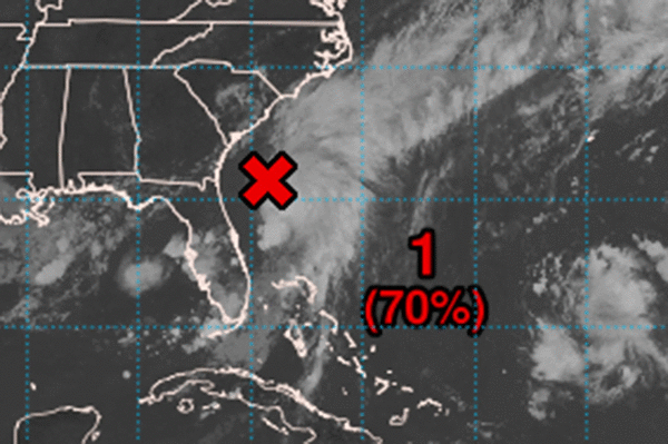
ORLANDO, Fla. — A tropical depression formed in the Atlantic off the coast of Florida on Friday headed for the Carolinas and expected to become a tropical storm, according to the National Hurricane Center.
In the NHC’s initial 5 p.m. advisory for Tropical Depression Three, its center was located about 100 miles east-northeast of Jacksonville, 150 miles south-southeast of Charleston, S.C. and 245 miles south-southwest of Wilmington, N.C. with maximum sustained winds of 35 mph as it moved north at 2 mph.
A tropical storm watch was issued for Edisto Beach to Little River Inlet, S.C.
“A slow motion toward the north-northwest is expected through Saturday, followed by a motion toward the north Saturday night and Sunday,” forecasters said. “On the forecast track, the center of the depression is expected to move near or over the coast of South Carolina Sunday morning.”
While reports from an Air Force Reserve Hurricane Hunter on Friday afternoon showed it at depression strength, the system is forecast to grow into what would become Tropical Storm Chantal on Saturday.
While the combination of the low pressure area and a stalled front over North Florida led to drenching rains across the state since Thursday, the rains centered around the depression are forecast to bring 2 to 4 inches with some areas getting as much as 6 inches to the coastal plain of the Carolinas from Saturday to Monday.
Storm surge could be from 1 to 2 feet above ground level along the coast along with rough surf and rip currents.
An intermediate advisory will be issued at 8 p.m. with a full complete advisory at 11 p.m.
The system became the third tracked storm of the 2025 Atlantic hurricane season.
It formed out of an area of low pressure that emerged about 100 miles off the coast of Jacksonville earlier Friday.
Heavy rainfall was expected to continue across a massive swath of the Florida peninsula through early Saturday.
The National Weather Service in Melbourne said the state was experiencing the release of a buildup of moisture that could drop several rounds of rain on parts of the state through Friday.
Similar rain on Thursday led to some local areas in Central Florida seeing 4 inches of rain.
“This is a reasonable worst-case scenario that persists for today`s storms as well,” forecasters said. “A few wind gusts from 35-45 mph have alow chance of accompanying the strongest storms.”
This is the first system of the year to threaten the U.S.
The National Oceanic and Atmospheric Administration forecasts 13 to 19 named storms this year, of which 6-10 will become hurricanes. Three to five of those would grow into major hurricanes of Category 3 strength or higher.
Hurricane season runs from June 1-Nov. 30.
------------
©2025 Orlando Sentinel. Visit at orlandosentinel.com. Distributed by Tribune Content Agency, LLC.


Comments